Crikey where does time go? Suddenly it’s Wednesday night and I’ve got 3days to catch up on. So let’s start with Monday morning. We had decided we would like to have a look at SWAN HILL, as some of the brochures we had accumulated, showed a few attractions we thought we would like to see. One was the Pioneer Village and Paddle Steamer at Swan Hill itself, and at nearby LAKE BOGA, there was a Catalina Flying Boat Museum and a Planetarium come Observatory.
To get to SWAN HILL from HORSHAM was going to mean a bit of ducking and diving across country as there are no main roads leading directly from one town to the other. However we had our good old reliable CAMP 5 book, and let’s not forget Know All Nancy.
Our first step was to continue north along the Henty Highway from HORSHAM to WARRACKNABEAL, a distance of about 50 km. From there our Camp 5 maps showed we could take a variety of different routes through various small towns, eventually winding up in SWAN HILL, a total distance of about 260km. Our problem was we had no idea of knowing how good the roads were, and whether or not they were suitable for the van.
So we asked Nancy for a route, and guess what, she came up with almost the same route we had chosen. She even assured us there were no ‘unsurfaced’ roads on her route. This sounded good enough for us, so off we went. By now you’re starting to wonder where this is leading, right?
We sailed up the Henty Highway to WARRACKNABEAL then turned sharp right and headed east towards the small settlements of LITCHFIELD and DONALD. As soon as we left WARRACKNABEAL we hit a long straight, and before I had to turn the steering wheel again, 22.8 km had passed. That was a new ‘straight road record’ for us, easily eclipsing the old record of 13.6km. Some of the road surfaces were a bit rough, but on the whole we were able to travel comfortably most of the time at between 90 and 100 kph.
Between HORSHAM and WARRACKNABEAL, the type of farming gradually changed from sheep to grain, and from there on it was all grain farming with huge flat paddocks either having just been harvested, or being disked and tilled ready for the next crop. There was also quite a bit of burn off evident, where they had burnt the stubble after the harvest. In fact, we had become quite used to seeing huge clouds of smoke on the horizon all around us where burn offs were in progress.
Some of the paddocks had road frontages of more than 3 or 4 km with the dividing fences disappearing into the mirages we could see in the distance. Farming on a completely different scale to what we are used to in NZ. There was also quite a bit of evidence of the January floods. Huge sheets of water lying wherever there was a bit of land lower than the rest. And of course, with the land being so flat, these areas often covered hundreds of acres. We knew from watching news reels back in January that a lot of this area had been under water during the floods.
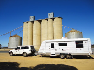
At LITCHFIELD, which is really just an intersection of two main roads, we stopped beside a cluster of huge grain silos, built between the road and the railway. Alongside the silos was a huge shed where the trucks dump the grain collected from the farms. Then it is augured up into the silos, before being loaded onto a train. We were to see two or three more of these set ups before we got to Swan Hill.
From LITCHFIELD we continued east to the small town of DONALD, where we stopped to admire an old steam engine which was on display beside the road. While Cameron and I were admiring the engine, Christel got chatting to a local who regaled her with stories about the recent floods and how close they had come to completely drowning the town.
At DONALD we swung north east on our last and longest leg to SWAN HILL. From here our Camp 5 map showed we would be travelling on minor country roads, but Nancy reassured us we were on the right track. You’re still wondering when it’s all going to turn to custard, aren’t you?
We stopped for lunch at DUMOSA, which again was just a place name where our road crossed the CALDER HIGHWAY, then headed off on the last leg of 95 km that would bring us out on the MURRAY VALLEY HIGHWAY, about 5 km south of SWAN HILL. So far so good, what could possibly go wrong?
We rolled in to our Motor Camp on the south end of SWAN HILL at about 3.00pm, after a trouble free trip through some real Australian countryside. See, all that worry by you for nothing. Just like to keep you reading!!!!

No comments:
Post a Comment